
We HCCD/FAX need your help to understand the impacts of this project and how it can be improved in the future. All questions are optional, and all personally identifiable information will be confidential. For any questions or concerns, please contact April Henry at april@highwaycitycd.com Thank you!I understand the purpose of this survey and that all of my personally identifiable information will be held confidential. I understand that I am free to stop at any time and skip any questions that I am not comfortable answering. I also understand that I have the right to contact April Henry, april@highwaycitycd.com to request to have my personal information erased from the record at any time.
The plan emphasizes the creation of complete streets that are not only functional for cars but also safe for pedestrians and bicyclists. These streets are designed to encourage walking, biking, and transit use, which aligns with the goal of multi-modal connectivity.
Multi-modal connectivity means having various convenient and accessible transportation options that work together efficiently. It means being able to move around using different options like walking, biking, public transit, cars, and ride-sharing.
Specific emphasis is placed on ensuring safe routes to school and connectivity to essential services.
West Development Area (DA-1 and DA-2), are expected to undergo significant investments in sidewalks and safe pedestrian crossings to improve accessibility and safety for residents.
Prioritizes the installation of crosswalks and other pedestrian infrastructure in neighborhoods that have historically been under served. Safe streets are vital to reducing traffic-related collisions and fostering a safer environment for children, residents, and commuters.
Provisions to address existing infrastructure deficiencies, particularly in areas that have lacked sufficient pedestrian and bicycling facilities. This includes enhancing public transit access, ensuring safe walking paths, and connecting key activity centers to residential areas.

Enhancing Access: Improve access to services and employment opportunities for residents in West Fresno.
Infrastructure Improvements:

Phase 1: Planning (December 2024 - June 2025):
Phase 2: Design, Construction, and Installation (June 2025 - April 2028):
Ongoing Activities:
Environmental Justice and Transportation Equity in West Fresno
Sustainable Transportation and Communities Division
California Air Resources Board
California Climate Investments
Fresno FAX

HAWKs (High Intensity Activated Crosswalk) are to aid in crossing the street mid-block. So instead of having to go all the way to a corner to use a crosswalk safely or even jaywalk just to get to a highly accessed area, a HAWK can be installed instead. Since many people haven't seen one yet, many drivers and pedestrians won't know how to use one.
HAWKs stay off most of the time so cars can keep moving. When someone presses the walk button, the signal wakes up. The yellow lights will flash to warn drivers to slow down. Then the light will turn red telling drivers to stop so people can cross. The light will turn off when everyone has crossed and traffic can flow again. It's like a traffic light that only turns on when someone needs to cross, keeping people safe while they cross.
Pedestrians
SEE
DO


09
Drivers
SEE
DO
Data was collected through public online surveys, accessible via both a web link and a QR code and distributed throughout Central Unified School District and Jane Addams Elementary via Parent Square and Principal's weekly e-blasts. Flyers were also sent out via other community benefit organizations like FIRM, Jakara, Jane Addams CDC, and via Housing Authority, Scouts, West area Neighborhood Watch groups and multiple social media platforms. These surveys served as the primary tool for gathering community feedback and input throughout the Safe Streets initiative.
The round 2 survey was out for the public to respond to from May 3, 2025 through May 23, 2025 and was responded to by 364 people who represented the community demographics in the similar proportions as our community census tract(s) information.
0
50
100
150
200
0
50
100
150
0
10
20
30


Overview: The project lead team consisting of Fresno FAX, City of Fresno PublicWorks, City of Fresno Long-term Planning, Highway City Community Development, Central Unified, Capital Planning, City of Fresno Council District 1, and Community Benefit Organizations: ENP, F.I.R.M, Jane Addams who have been part of outreach, came together on July 25th to look at all the factors that were part of the system to weigh feasibility and viability of the project areas chosen from 2 surveys (results online), multiple community outreach opportunities including parent group forums and a community Open House and a West (Project) Area Resident Advisory Panel on the Top 10Sidewalk and HAWK locations identified for potential selection.
Included in that scope for the selection criteria and its weighting were: Community Engagement & Survey Results (20%), Planned Proximity to other Planned Improvements (20%), Areas with Limited Bus Service (20%)making up the 3 largest factors at 60%, with the remaining factors to feasibility including, Proximity or Pathways to Schools (15%),Crash/Safety Data (10%), Connectivity to Key Destinations (10%) and CalEnviro Screen 4.0 environmental and disadvantaged areas factors(5%).
All of those factors were layered into GIS maps which then gave the project lead team the actual ranking of the top ten (10) locations in order of need with the factors applied. The overall project grant has a set funding budget, and the factors layered in through the work of the Public Works team, gave a estimated cost to each sidewalk section and HAWK proposal.


Sidewalk Segments Chosen pending final cost feasibility reports:
Funded/Planned Improvements:
Other notes of interest:
McKinley from Dower Ave to Marks Ave
Olive Ave from Hayes Ave to Hughes Ave
HAWK Locations Chosen pending final cost feasibility reports:
Funded/Planned Improvements:
Back-up Locations/ Future Planning:
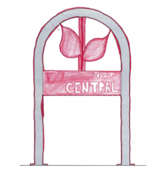
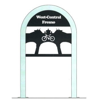
Congratulations to the two winners of the design contest Amryna Bajwa(Youth winner) and Gene Ven Yang(Adult Winner)!
What’s this all about?
West-Central Fresno currently lacks bike racks — an important part of helping people bike safely and store their bikes at key locations like the library, parks, community centers, and local shops.
Other areas like the Tower District and Downtown Fresno have unique, artistic bike racks that add both functionality and neighborhood flair — and now it's our turn to bring that same energy to West-Central Fresno!
Thanks to funding from the Sustainable Transportation Equity Project (STEP) and partnerships with:
This first phase of the project will include:
New bike racks
HAWKs (Pedestrian-activated crosswalks)
Up to 1.5 miles of new sidewalk in our neighborhoods
Here’s how you can be part of it:
Winners:
Two winning designs will be selected: Youth (under 18) & Adult (18 and older)
These designs will be fabricated and installed as real bike racks throughout the West-Central area — giving the winners lifetime artist bragging rights!
Questions?
Email us at: info@highwaycitycd.com
Following the close of the Bike Rack Design Contest, all submitted entries will be compiled into a judging book. Each entry will:
A judging panel consisting of a minimum three community artists will review all submissions. *The fabricator will be part of the process for feasibility of design.
Judging Process
JudgingCriteria (Scoring Rubric)
Each design will be evaluated on a 1–5 scale (1 = Needs Improvement, 5 =Excellent) in the following categories:
Note: Because of the number of entries AND the complexity of the judging criteria winners will be announced at our Annual Community Events- Santa’s Village – Saturday, December 6th. Winners will be notified by mid-November.
Highway City Community Development, Inc.
4718 N. Polk Ave.
Fresno Ca. 93722

Community Resource Center
4718 N. Polk Ave.
Fresno CA 93722
559-578-8991


